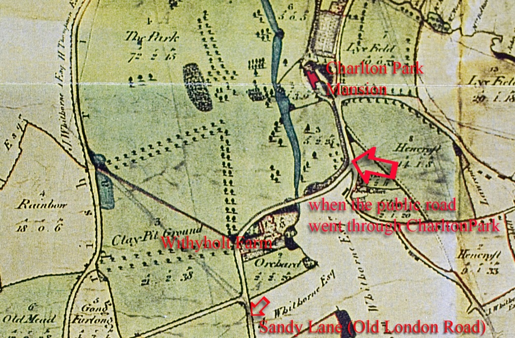
 © Glos ArchivesThe 1811 estate map shows the public road (part of old 'Hollow Way') that ran from Sandy Lane through Charlton Park before a section of it was diverted to become 'New Way' after 1784 (today's Moorend Road)The earlier continuation of Sandy Lane ran straight up through the park, past Withyholt and was called 'Sandy Road' by Mr Prinn
Charlton Park and its mansion was called Forden House or simply The Forden until 1784 and gave its name to the nearby Forden brook (today's Lilley Brook or Lilleybrook). It was bought by a branch of the great Cotswold sheep-owning and wool-growing family of Greville in 1386/7 when William Greville of Chipping Campden bought Ashley manor, alias Charlton Kings, including Charlton Park, and his family owned Charlton Park for the next 300 years, with other property interests in Gloucestershire and beyond. The Charlton Park family of Greville seems to have been less famous than other branches of the clan, but they remained here for eight generations, and John Greville the younger was knighted before 1470. In the Civil Wars of Cromwellian days the Charlton Park Grevilles seem to have taken no part, but their sympathies were apparently not Royalist.
The Greville's long tenure came to an end in 1698 when the Forden was sold to John Prinn senior for £725 (Prinn already owned nearby New Court). The Grevilles had encumbered the estate with various mortgages and settlements, and it could not be sold with good title until all these were cleared away. Prinn and a business partner, George Venn, advanced £725 for it in 1698 but it was not until 1701 that the conveyance was completed, at which time Giles and Ann Greville released to John Prinn alone for the same £725 the capital messuage (Forden House) and nearly all the land that went with it, reserving a few closes. There was still one outstanding mortgage to Thomas and Anthony Jorden which Prinn took over and this was cleared in 1702. Prinn was not a wealthy man but he was prudent, earning a reasonable income from his legal work and his rents. Improvements to the estate had to be spaced out, roughly one major effort every other year and this commenced around 1709, when he started to extend the south wing of the house. Another main improvement was to the Home Farm, situated between the house and the diverted Hollow Lane. The old barn and stable were removed and a new barn and stable erected (the old stable block is now the only surviving part of St Edward's School beyond the house itself) the buildings shown by Robins in his c1740 painting. In 1724 he had a new cider mill erected and in 1732 a new end to the south wing of the house, this date being cut into one of the big timbers in the upstairs south corridor.
Hollow Lane crossed the Forden brook or Lilleybrook by a ford which was gated to prevent cattle getting into growing crops. In 1612 inhabitants with land in the Lower Field were ordered to contribute to the cost of gates at The Forden. Presumably there was a hedge or fence along the bank as well, or cattle might have been tempted to wade across. By the end of the 17th century at least there was a footbridge and stile. On 9 April 1695 Ralph Thomas was presented in court for cutting up the stile and gateposts. This time Greville, as owner of The Forden was ordered to replace them, a hint that as owning adjacent land they had been negligent in not preventing the damage and Ralph Thomas may have resented the recent innovation!
A rudge (strip of ridge-and-furrow) abutting on Le Forden Bridge was surrendered on 11 December 1699 but this may still have been a footbridge only. On 13 April 1700 Richard Whitehorne and his wife surrendered to use of John Prinn several closes and also one selion (a strip of land, such as ridge-and-furrow, sometimes owned or rented by peasants) on le Forden Bank abutting le Forden footbridge. It is not until 1725 that there is a definite reference to a cart bridge. Then on 21 August John Prinn came to an agreement with Samuel Whitehorne about the 'way' he should take to get from his house in Moorend to his land in Pilford. Whitehorne was to come down Moorend Street and over "the arched bridge of the said John Prinn" and then straight up to the Grene Way (once called Hester's or Haysters Way). If Prinn paid for a carriage bridge, he was entitled to consider it his. The account books shows Prinn in 1709-10 paying for "work at the bridge" but without further detail.
John Prinn's arched bridge was part of his "New Way" to Charlton Kings (now Moorend Road) and was one of the first improvements after he took possession in 1701. On 7 May 1703 Anne Higgs, widow, surrendered to use of John Prinn all her lands at Benbreach field (against Old Bath Road - see 1746 Estate Map above). Her land ran E-W on the brook and lay between a headland, formerly owned by Richard Whitehorne, now sold to John Prinn and "the new way made by the said John Prinn leading into Charlton Kings". Prinn was diverting Hollow Lane slightly away from his house. Robins' painting shows the road coming south and west of the Home Farm, then at a distance from the west end of the house before taking a definite angle to run down to Sandy Lane. Whilst the 1746 Estate Map shows this road more or less straight, Robins' bend is probably more nearly right. At the same time Prinn was making his 'New Carriage Drive' up to the north side of the house, to create a Visitors' Entrance. It was to start on Sandy Lane and run through an avenue of young trees parallel to the public road.
Prinn could now make this new drive because he had bought part of the land of the 15th century 'Park Cottage' beyond his kitchen garden (today called Charlton Park Cottage, in St Edward's Walk). In 1709 the owners, William and Francis Jelf divided their house and land and surrendered to John Prinn a close and part of the orchard near the house, as well as a selion on Forden Bank.