Normally, anyone attempting to describe the history of an area like this would begin by making reference to the earliest traces of man within the bounds of what later became Charlton Park. In this instance I'm afraid you can quickly forget any meaty description of things from Neolithic to Norman times, during which countless lives were lived out around here, leaving us with words like 'scant' and 'non-existent' in trying to offer the reader some account of matters during the first millennium AD. Tangible artifacts are exceedingly rare and written records non-existent, a situation that didn't improve much until early in the second millennium, a thousand years after the Romans arrived. In 1086 King William famously sought to improve his own local knowledge by instigating a thorough survey of his newly acquired lands, after adding 'Britannicar' to his ever expanding land and property portfolio. Charlton Park does not feature in his 'Domesday' record of Gloucestershire indicating it was general farmland with no need for specific mention.
Whilst there must have been occasional discoveries in the soil (and plentiful sand) during recent millennia, very little has survived until today, unless someone now advises otherwise. One bit of evidence emerged from the time when Bovis Homes prepared the ground for development after 1976, when Bernard Rawes, an amateur archaeologist found numerous worked flints in the centre of 'Old Park' (that part on the west side of Lilley Brook). They were thought to have come from a Neolithic 'chipping floor' - where a skilled person once squatted to fashion sharp-edged tools by knapping pieces off flint cores. Pottery sherds were also found but they were so scattered and abraded that nothing significant could be deduced. Consequently, the absence (or failure to survive) of more typical archaeological evidence - of construction, occupation, habitation and burial, supports the view that the surface of Charlton Park was used for little more than hunting and agriculture during recent millennia. As a result, unless anyone (maybe a Bovis employee) now knows differently, the lack of artifacts from the massive time-span we call 'pre-history' simply confirms the usual fact, that its great unwritten legacy once again conceals from us the identities, stories and structural remains of the very real people who once tilled, cropped, cultivated, hunted and lived out their comparatively tough lives in this well watered, pleasant Cotswold lowland area.
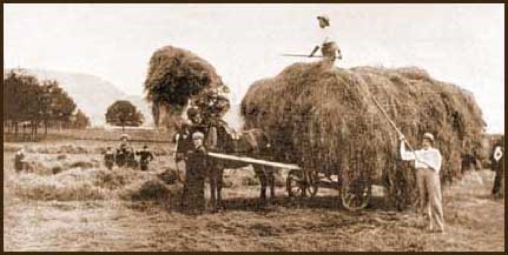 © Cotswold ImagesHaymaking in Charlton Park in 1903 - with Leckhampton Hill in the background.
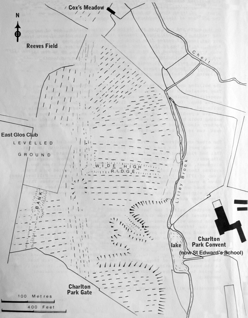 © J RawesBernard Rawes' 1979 sketch plan of Charlton Park's historic ridge and furrow cultivation strips and
several field systems. Traces of two ancient routes crossing the park were also visible for the last time.The old London Road (Sandy Road) is the route running from Charlton Park Gate to Cox's Meadow
Consequently, by the time Bovis Homes commenced building over 'Old Park', having purchased some 29 acres of Charlton Park west of the Lilley Brook in 1975, pretty much all that remained visible were many beautiful old trees, fading traces of old roads, numerous ridge and furrow cultivation strips and their plough headlands. Prior to it becoming an ornamental and recreational deer-park in the 18th century it appears the surface had been arable throughout earlier centuries, as well as left for grazing by deer and other livestock, or swathing for hay and corn, before during and after the 17th and 18th Century landscape, waterscape and tree planting work. In the 1970s Bernard Rawes' ground inspection interpreted some five ridge and furrow field-systems, massively heaved-up during earlier centuries of ox-ploughing and manual cultivation, which with some field boundaries could all be seen until about 1976. A wide track-way crossing the park was also discernible, which he believed was once part of a London to Cheltenham route during the eighteenth century and much earlier. It is believed to have forked under what is now called Reeves' Field to join the Old Bath Road, the other 'fork' crossing the River Chelt at Sand-ford, near Sandford Mill, where another ancient route ran north to Prestbury along Cheltenham's east parish boundary.